Floods are the costliest and most frequent natural disaster in Malaysia, displacing tens of thousands of people and causing billions of ringgit in damage almost every monsoon season. The hard truth is that the climate has already changed — rainfall is more intense and less predictable — so the question is no longer whether to forecast floods, but how to predict them early and accurately enough to act. H2O Datatech has pioneered an answer: a machine-learning approach that turns fragmented environmental data into basin-scale flood risk intelligence, delivered through our Airnomik© platform.
What is machine-learning flood risk prediction?
Flood risk prediction is the practice of estimating where, when and how severely flooding is likely to occur, so that agencies and communities can prepare before water levels rise. Traditional approaches rely on physically-based hydrological models that are accurate but slow to run, hungry for calibration data, and difficult to update in real time.
Machine-learning flood prediction takes a different path. Instead of solving the physics from scratch every time, models learn the relationships between rainfall, river levels, soil saturation, terrain and historical flood events directly from data. Once trained, they can generate fast, continuously updated risk estimates as new observations arrive — turning a slow, reactive process into a proactive, near-real-time one.
Why floods demand a data-driven approach in Malaysia
- Monsoon rainfall is becoming more intense and erratic, so the past is no longer a reliable guide to the future.
- River basins span many agencies and data silos, making a single, connected view of risk difficult to assemble.
- Conventional models are powerful but too slow to re-run for every storm, limiting their value for live early warning.
- Decision-makers need lead time — not just a forecast after the water has already risen.
How machine-learning flood prediction works
The starting point is data integration. Rainfall records, river and water-level gauges, terrain and elevation models, land use, soil characteristics and historical flood footprints are brought together into one consistent, spatially-aware dataset.
From there, models learn the signature of a flood: the combinations of antecedent rainfall, saturation and river response that precede an event. Because the model is trained on real outcomes, it captures local behaviour that generic assumptions miss — and it keeps improving as more data accumulates.
Crucially, the output is not a single number. It is a continuously updated, location-specific risk picture that planners can interrogate by zone, by scenario and over time — supporting decisions hours or days before a flood, not after.
How H2O Datatech pioneered it with Airnomik©
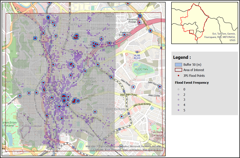
Airnomik©, our spatial decision support system, applies big-data analytics and machine learning to model flood and pollution risk across an entire river basin. It operates as a living digital twin of the catchment — ingesting environmental data and translating it into clear, risk-based insight for the agencies responsible for protecting communities.
Rather than treating flood prediction as a one-off study, Airnomik© makes it operational: risk is profiled continuously across the basin, visualised on web-based GIS maps, and made shareable across agencies. This is the same data-driven foundation we presented at the International Conference on Water Resources (ICWR) 2025 as a digital twin for the operationalization of Integrated River Basin Management.
The impact: from reactive response to early action
- Earlier, evidence-based warnings give communities and responders more time to act.
- A single basin-wide view replaces fragmented spreadsheets and disconnected agency data.
- Scenario testing lets planners see how the basin responds to extreme rainfall before it happens.
- Continuously updated risk profiling supports both climate adaptation and long-term resilience.
Frequently asked questions
Is machine learning replacing traditional hydrological models? No — it complements them. Physically-based models remain valuable for understanding mechanisms, while machine learning excels at fast, continuously updated prediction at scale. The strongest systems combine both.
Does flood prediction require perfect data? No. A major advantage of a data-driven platform is that it makes the most of the data that exists today, integrating multiple imperfect sources into a coherent picture — and gets better as monitoring improves.
Who benefits from this? Regulators, water agencies, local councils and utilities responsible for flood preparedness and Integrated River Basin Management, as well as the communities they protect.
Key takeaways
- Floods are Malaysia's most damaging climate hazard, and intensifying rainfall makes the past an unreliable guide.
- Machine learning turns slow, reactive flood forecasting into fast, continuously updated risk prediction.
- Airnomik© operationalises flood intelligence at full basin scale, supporting earlier action and stronger resilience.