Under the theme “Embracing Change for a Resilient Future in Water Resources,” H2O Datatech took the stage at the International Conference on Water Resources (ICWR) 2025 in Putrajaya. Dato’ Ir. Mohd Azmi Ismail, with co-authors Simon Chan and Punita Nook Naidu, presented how Airnomik© — our data-driven digital twin platform — operationalizes Integrated River Basin Management (IRBM) through Total Maximum Daily Load (TMDL) analysis, climate risk screening and machine learning.
The operationalization challenge
Integrated River Basin Management is widely endorsed in policy, but operationalizing it on the ground remains difficult. The data needed for sound decisions is fragmented, and the people who must act on it often lack the analytical tools to do so.
- Existing data is siloed across different agencies, and limited access to climate and geophysical data restricts comprehensive planning and monitoring at the local scale.
- Local agencies and communities need deeper insight into asset-level risks and vulnerabilities.
- A unified, user-friendly platform is required to guide resilience planning for non-technical users.
A digital twin for IRBM
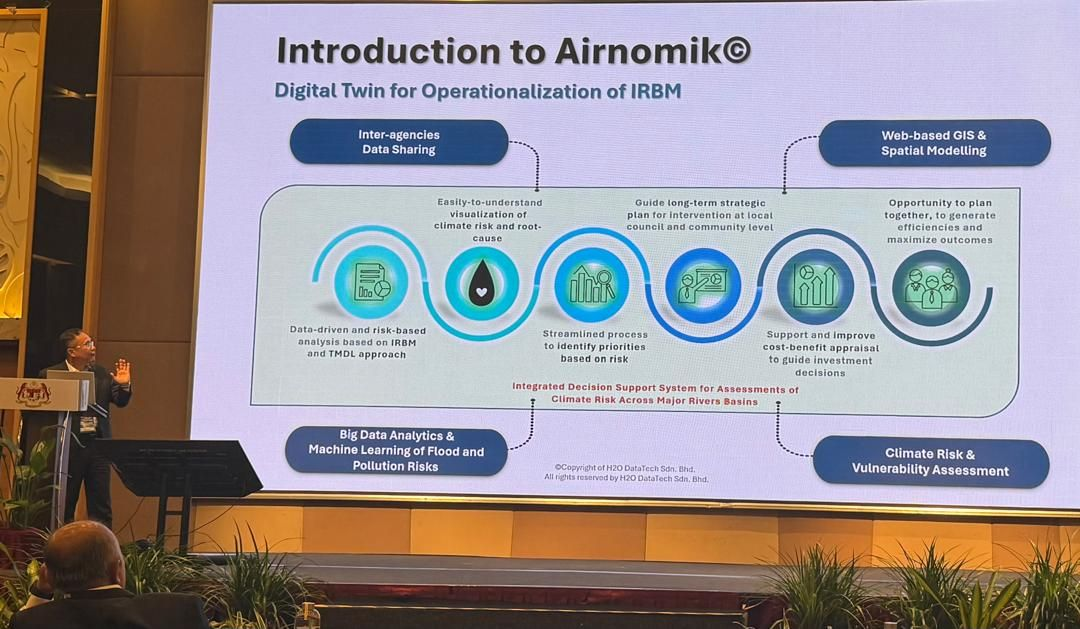
Airnomik© is an Integrated Decision Support System for assessing climate risk across major river basins. As echoed in AIR2040 Vol. VII, climate change risk, impact and vulnerability assessments are best conducted at the river basin or local scale alongside operational agencies — enabling a step-wise approach that identifies near-term disaster risk reduction and long-term, affordable climate adaptation options.
- Data-driven, risk-based analysis grounded in IRBM and the TMDL approach.
- A streamlined process to identify priorities based on risk and guide long-term strategic intervention at local council and community level.
- Support for cost-benefit appraisal to guide investment decisions, with easy-to-understand visualization of climate risk and root cause.
- Built on inter-agency data sharing, web-based GIS and spatial modelling, and big data analytics and machine learning of flood and pollution risks.
Simplifying decisions with the LEAP framework
Airnomik© structures risk screening and prioritization around a simple, repeatable cycle that any stakeholder can follow — LEAP:
Learn
from all available data — monitoring, GIS and socio-economic information.
Evaluate
spatial intelligence on climate exposure and risk through an interactive platform.
Act
by prioritizing interventions and allocating resources where the impact is highest.
Progress
by tracking outcomes, measuring results and refining strategies for continuous improvement.
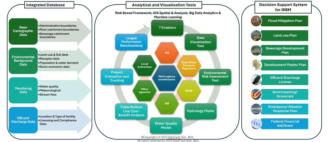
Inside the platform: seven enablers
Airnomik© unifies a multi-agency integrated database — base cartographic data, environmental background data, monitoring data and effluent discharge data — with analytical and visualization tools serving JPS, SPAN, JAS, state water resource regulators, local authorities and other agencies.
- Data Visualisation Tool and Environmental Risk Assessment Tool.
- Hydrology Model and Water Quality Model.
- Triple Bottom Line Cost-Benefit Analysis.
- Project Evaluation and Tracking, and League Performance Benchmarking.
Operationalizing climate-resilient IRBM
The platform embeds risk screening directly into the approval workflow for local councils and state governments. Developers submit proposals detailing location, discharge and land-use plans; Airnomik© then automates the analysis of project and asset risk and resilience rating.
Projects are categorized by impact and exposure: green-flagged premises proceed to the next stage of licensing, while yellow- and red-flagged premises are subject to further risk screening, with stricter conditions imposed to mitigate risk where necessary.
Case study: Batang Rajang TMDL, Sarawak
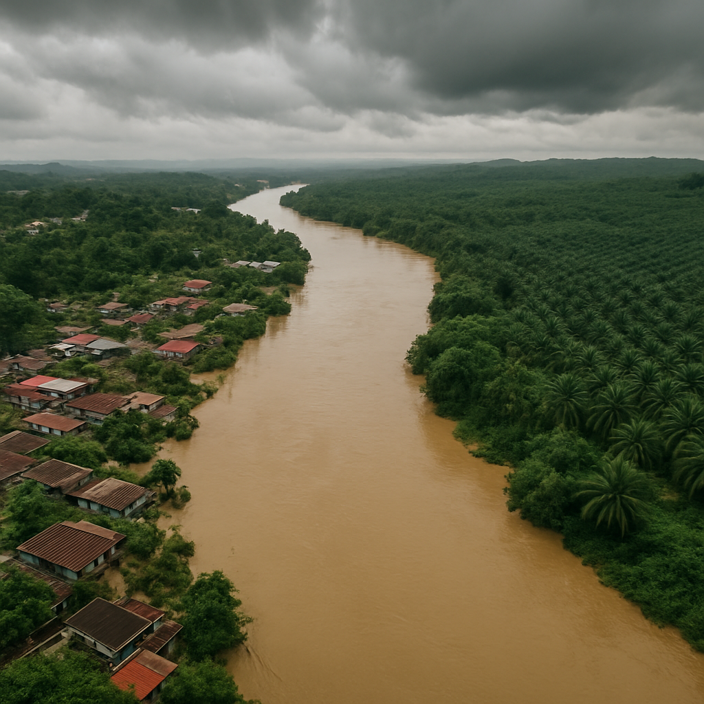
For the Government of Sarawak, Airnomik© was deployed for pollution risk screening and dynamic TMDL planning across the Sg. Rejang basin — Malaysia’s largest river basin at roughly 51,000 km², frequently impaired by natural and anthropogenic activity that threatens aquatic ecosystems and local livelihoods.
- Mapping of sensitive receptors, pollution sources and impaired water body status via the Environmental Risk Assessment module.
- Real-time TMDL analysis, pollutant ranking and seasonal load variation through the TMDL Analysis Module.
- Effluent impact and compliance monitoring through Pollution Source Risk Assessment.
- Impact: reduction of high-risk pollution hotspots to under 20% of catchment area, with real-time TMDL analysis enabling targeted interventions.
Case study: AI-ML for flood prediction
Funded by Cradle, this project built an AI-driven climate risk model combining machine learning with satellite remote sensing to improve flood prediction accuracy and streamline river basin decision-making.
- Machine learning algorithms (Random Forest, XGBoost, Neural Networks) for streamflow and flood inundation prediction.
- Streamflow modelled best with Random Forest (R² > 0.78); flood inundation with XGBoost (F1 > 0.69, recall > 0.85).
- Satellite remote sensing integrated with local hydrological data to sharpen model precision.
- Impact: enables dynamic flood mitigation planning, outperforms traditional hydrological models, and reduces reliance on manual data collection and costly physical modelling.
Benefits and national alignment
Across use cases, Airnomik© turns complex datasets into easy-to-understand risk assessments — enabling enhanced decision-making, health-risk prioritization, strategic resource allocation, and a customizable, scalable platform tailored to local conditions.
It is designed to advance national and agency goals, aligning with RMK-12, AIR 2040 and the wider agenda of advancing green growth for sustainability and resilience while transforming the water sector.
Key takeaways
- Airnomik© operationalizes IRBM as a data-driven digital twin built on TMDL and risk-based analysis.
- The LEAP framework — Learn, Evaluate, Act, Progress — simplifies risk screening and prioritization for non-technical users.
- Seven enablers unify multi-agency data with hydrology, water quality, cost-benefit and tracking tools.
- Proven in practice: Batang Rajang TMDL in Sarawak and a Cradle-funded AI-ML flood prediction model.
- Airnomik© aligns with RMK-12 and AIR 2040 to advance climate-resilient water management in Malaysia.